Maryland Historical Trust staff carries out fundamental research into the archaeology of
Maryland, both historic and prehistoric, on the land and in the water. This research involves
fieldwork, analysis of archaeological collections curated by the Maryland Historical Trust,
and synthesis of existing archaeological data. Below are a few examples of the
MHT's archaeological research.
MHT’S ARCHAEOLOGICAL SYNTHESIS PROJECT, begun in
2007, is an ambitious attempt to make
cultural resources management’s “grey literature” more accessible to researchers,
planners, and the general public. The project—largely undertaken by Dr.
Matthew McKnight—is examining Phase II and Phase III investigations undertaken in
Maryland during the past four decades, culling out the most important findings
of those studies, and organizing the archaeological data in a searchable database.
Funding has been provided by the MHT Board of Trustees and the Maryland
State Highway Administration’s Transportation Enhancement Program. To date, nearly
1200 reports have been examined and synthesis reports have been prepared for
more than 1000 sites. For a more detailed look at MHT’s archaeological synthesis
project, click here.
» LEARN MORE ABOUT THE
ARCHAEOLOGICAL SYNTHESIS PROJECT
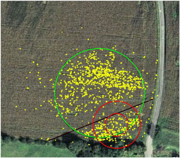
THE BIGGS FORD SITE is one of the first archaeological sites excavated by state
archaeologists in Maryland, with salvage excavations undertaken in 1969 prior to installation
of a sewer interceptor. Excavations revealed what appeared to be two overlapping
Late Woodland villages—one from the Montgomery Complex, and one from the Keyser
Complex. In the spring of 2009, the site was plowed for the first time in many years,
and State Terrestrial Archaeologist Charlie Hall quickly arranged permission to carry out
a controlled surface collection designed to test the notion of overlapping circular
villages. Using a total station, the precise location of every potsherd seen on the surface
in the vicinity of the Biggs Ford site was collected along with the
artifact. (Pottery was targeted as it promised the ability to distinguish between the
two villages, while both the Montgomery and Keyser villages would be characterized by
similar lithic assemblages.) More than 1,100 potsherds were collected, and the fit
between their distribution and the two projected circular villages was quite close,
supporting the interpretation of previously mapped features and the proposed two village
hypothesis. As part of the Annual Field Session in Maryland Archaeology,
MHT archaeologists—in cooperation with the Archeological Society of Maryland, American University,
and Towson University—returned to Biggs Ford in 2013 to undertake 11 days of excavation;
that work continued during the 2014 add 2015 field sessions.
HEATER'S (CONOY) ISLAND,
located in the Frederick County portion of the Potomac River,
served as the site of the last permanent Piscataway Indian settlement in Maryland,
from 1699 to around 1712. Here, in relative isolation, the Piscataways erected a
fort, established a thriving community, survived a 1704 smallpox outbreak, and saw their
population rebound before ultimately abandoning the island and migrating to Pennsylvania
and parts north. In 1970, the University of Maryland–College Park held its first
archaeological field school (at the time, one of only five in the country to
investigate Contact period sites) at Heater’s Island, under the direction
of Robert L. Schuyler. The 10-week session resulted in the excavation of
120 five-foot-square units, recovered a wide range of trade artifacts, and
exposed a number of features, including a bastion of the fort. Due to various
circumstances, however, a site report was never prepared, and the artifacts and
site records remained in storage with Schuyler at the University of Pennsylvania.
The Maryland Historical Trust sought to have the Heater’s Island collection returned
to Maryland (the island is now state property, having been purchased in 1972), and
in 2004 the transfer was accomplished. Since that time, Dennis C. Curry has
worked to prepare a site report—now nearly complete—for the 1970 excavations.
» "We have beene
with the Empeour of Pifcattaway, att his forte": The Piscataway Indians on Heater’s Island
(Dennis C. Curry, presentation at 2014 Middle Atlantic Archaeological Conference)
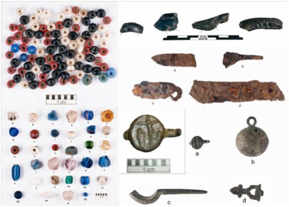
NAVAL ENGAGEMENTS of the
Revolutionary War and the War of 1812 in Maryland were
the focus of a study conducted by the Maryland Maritime Archaeology Program and New
South Associates, Inc. between 2010 and 2013. The project was supported by
a grant from the National Park Service’s American Battlefield Protection Program,
and built upon previous collaborative efforts involving the Maryland Historical
Trust, the Maryland Tourism Development Board, the Maryland War of 1812 Initiative,
and the National Park Service’s American Battlefield Protection Program.
The current work involved battlefield analyses utilizing the METT-T approach and the
KOCOA method related to six naval engagement sites in Maryland: the loss of Cato and
Hawk at Cedar Point (1781); the Battle of Kedges Straits (1782); the raids on
Frenchtown and Elkton (1813 and 1814); the raids on Georgetown and Fredericktown
(1813); the Battles of St. Leonard’s Creek (1814); and the Battle of
Baltimore (1814). Battlefield analyses guided reconnaissance-level underwater
archaeological fieldwork intended to identify areas with potential to contain physical
evidence of the engagements. Results and recommendations are included
in the final report "Naval Engagements of the Revolutionary and 1812 Wars in Maryland".
»
Naval Engagements of the Revolutionary and 1812 Wars in Maryland
(National Park Service report, 2013)
FOR MORE THAN A CENTURY, anthropological
and archaeological literature has repeated
variations of the statement that the Piscataway (Conoy) Indians “made their
last appearance as a separate tribe at a council held at Detroit in 1793.” Often
added to this remark were the facts that the Piscataways used a turkey symbol
as their signature, and only 50 tribal members remained in 1793. Dennis C.
Curry examined these statements in detail, concluding that one is flat-out
wrong, one is true, and one is plausible.
» A
Closer Look at the "Last Appearance" of the Conoy Indians (Dennis C.
Curry, Maryland Historical Magazine 106(3), Fall 2011)

ENIGMATIC BIRDSTONES have intrigued
antiquarians and archaeologists in eastern North America
for more than a century. In 1959, Earl C. Townsend, Jr., published a descriptive
compendium entitled Birdstones of the North American Indian, which illustrated hundreds of
known birdstones. Yet, little is understood about these rare artifacts and—especially
in Maryland—they have received little serious study. In fact, in 2009 a published survey
of birdstones from the northeastern United States asserted that “no examples of
birdstones are known from Maryland.” Knowing that this was not the case,
Dennis C. Curry set out to document the handful of specimens of which he
was aware. The list of Maryland birdstones soon grew to more than a dozen
examples, representing nine Maryland counties, and leads on others were
gathered. Clearly these stone carvings were a notable part of Maryland
prehistory and—once an accurate inventory is compiled—warrant in-depth
investigation. Read Curry’s article from Pennsylvania Archaeologist.
» Birdstones:
Some Clarifications from Maryland (Dennis C. Curry, Pennsylvania
Archaeologist 80(2), Fall 2010)
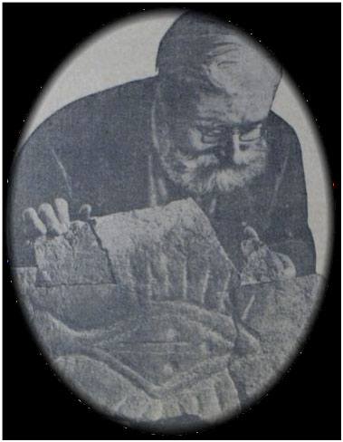
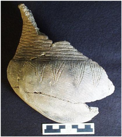
THE BALD FRIAR PETROGLYPHS have inspired
public curiosity since colonial times, and have
been the object of scientific study for more than a century. Originally located on
a series of small islands in the lower Susquehanna River, the petroglyphs were
threatened by construction of the Conowingo Dam in the late 1920s. In response
to this threat, members of the Maryland Academy of Sciences sought to retrieve the
glyphs before they could be inundated by the Conowingo reservoir. Dynamite was
used to extract the glyphs from the rocky outcrops, freeing the glyphs, but
damaging many in the process. The better-preserved and more fully-reconstructed glyphs
were put on display in various parts of the state, but perhaps the bulk of
the removed stones were eventually stored in a pile on the grounds of Druid Hill
Park. In early 2006, State Terrestrial Archaeologist Dr. Charlie Hall and the Office
of Archaeology worked with interested parties to transfer these stored glyphs to Jefferson
Patterson Park and Museum, where they can be preserved, studied, and
made available for display. The actual move of the glyphs took place during the spring of 2006.
» LEARN
MORE ABOUT MARYLAND PETROGLYPHS
» LEARN
MORE ABOUT THE MOVE
THE ROSENSTOCK VILLAGE SITE—one of
the largest and best-preserved components of
the Late Woodland Montgomery Complex—was excavated by the Archeological Society
of Maryland, Inc. in cooperation with the State's Office of Archaeology in
1979 and 1990-1992. The 1.5-acre site, located on a bluff overlooking the
Monocacy River in Frederick County, is roughly circular as indicated by an
arcing line of trash-filled pits. No palisade has been found at the
site despite concerted efforts to locate such a feature. Likewise, postmold
patterns for domestic structures have yet to be discerned, although
some household features point to general house locations. Two
semi-subterranean “keyhole” structures—presumably sweatlodges—have
been identified. The artifact assemblage is predominated by Shepard ware
ceramics, as well as implements of quartz, rhyolite, and bone. Subsistence
evidence includes carbonized corn and beans and a wide array of faunal remains
including mammals, birds, reptiles, and fish. Radiocarbon dates roughly place
the site in the A.D. 1335-1400 time period.
» Excavations
at the Rosenstock Village Site (18FR18), Frederick County, Maryland: A Preliminary Report
(Dennis C. Curry and Maureen Kavanagh, Maryland Archeology 40(1), March 2004)
THE MARYLAND MARITIME ARCHAEOLOGY PROGRAM undertook
a cooperative effort with
Department of Natural Resources staff to research and reconstruct a shipwreck
found in Martinak State Park. Known as the “Martinak Boat,” the wreck
has been described as the wooden remains of a 19th century Pungy schooner,
a vessel type whose beginning is generally accepted to be the late 1840s.
Pungies were oyster and fishing boats that plied the Chesapeake Bay until
the late 19th century. While photographs and drawings of pungies exist,
verified wreck remains or construction plans have yet to be found. As
a result, without corroborating artifactual evidence (no artifacts were found on
or near the wreck site), the exact date for this boat may never be
known, although there are certain construction details and fastener types that
may indicate an older date for the vessel. Adze (woodworking tool) marks,
fasteners, and construction style hint that the vessel may be a schooner or
sloop dating to between 1780 and 1820. The reconstructed timbers from
the “Martinak Boat” are on public display at Martinak State Park in
Caroline County.
» The
Martinak Boat (CAR-254, 18CA54), Caroline County, Maryland
(Bruce Thompson, MHT Report, 2005)
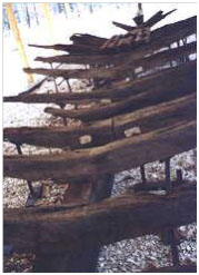
THE WATER-SATURATED REMAINS of a large wharf structure were investigated
at 18th century Pemberton Hall near Salisbury on Maryland's Eastern Shore.
The squared timbers, some of which exceed 18 inches in diameter, are located
in a tidal flat and are believed to be part of historic Mulberry Landing.
Work included both the illustration and photodocumentation of the wharf components
and associated construction debris and artifacts. Dendrochronology dating undertaken
on the timbers revealed that the wharf had to have been constructed prior
to 1748. The project to uncover and document the remains was undertaken by
volunteers from diverse backgrounds and interests under the auspices of the
Board of Directors of Pemberton Hall in cooperation with Maryland State
Underwater Archaeologist, Dr. Susan Langley.
»
"Tongues in Trees: Archaeology, Dendrochronology, and the Mulberry Island Wharf"
(Susan B.M. Langley, Maryland Historical Magazine 95(3), Fall 2000)
